In this modern economy we have all come to depend on the oil and gas industry for our livelihood. They not only help fuel our cars and heat our homes, but also produce the plastic we so commonly use as well as the many lubricants, waxes, tars and asphalts.
Refineries and plants spread across the world including the USA, Middle East, Russia, China, and Latin America testify to one challenge – the need for real-time situational awareness.
While extracting oil and gas there are a few challenges concerning plant managers:
- Safety of the teams
- Spills and explosion prevention
- Theft and pipe tapping
To manage these situations, plants take various precautions that include:
1. CCTV cameras set across the location
2. Drones and UAV monitoring
3. First response teams and regulations
4. Security personnel
The data streamlined from these sources is gathered at a central Command & Control station, where 24X7 monitoring takes place, while equipped with state of the art hardware and software. These include large monitoring screens, communication platforms, analytical tools – all to make the process a little easier to control by the personnel.
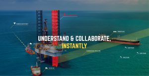
Layers of critical information in real-time
Edgybees augments live video feeds with precise geo-information layers to provide oil & gas plants immediate situational awareness. The video can be captured from any camera, human input or other data sources and help understand the situation, communicate immediately, and take control.
Let’s examine one example scenario, to see how the Edgybees solution works:
It is 10 in the evening, the C&C station receives alerts of a possible pipe leak, change in pressure or heat. The staff immediately look at images coming in from the CCTV cameras, and also get a drone up in the air for a closer view. The problem is detected, and all information is layered on the video in the form of shapes and text, along with the maps and distances. The information is then streamlined to the teams on the ground in one clear lie video which includes all details. The first responders can now view the live visual data on their mobile devices, and their location is also layered on the video. Staff on the ground, at the command station, in the air can immediately correspond to get a hold of the situation until it is concluded.
This example is one of many, demonstrating the time saved along with a full clarity while managing critical situations.
For more information on the Edgybees technology, contact us today!